I needed to use exUSSR military maps for Georgia (Caucasus) together with a Garmin GPS and OziExplorer.
What I gathered as for now, the maps:
- Probably use Krassovski ellipsoid
- Use the Transverse Mercator projection
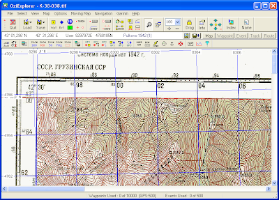
Steps to load and calibrate the map in OziExplorerThis was done with a registered version of OziExplorer, v3.95-4q and a scanned 1:100 000 map K-38-038 of the Lentechi region in Svaneti, Georgia.
- Open the scan using "Load and calibrate map image" menu item.
- Set up the map datum - the map says that it's in the Coordinate system 1942. There are three systems that give similar results in OziExplorer, I used the first Pulkovo (1) system:
 I left the Mag Var (magnetic variation) empty.
Small update: It seems that the values better agree with what the GPS will give if the S42 is used instead of Pulkovo map datum. This gives differences about 2-10 meters (which is OK in most cases for me).
- Set up the map projection is more tricky. The map uses Transverse Mercator with zones six degrees wide. That is, to make a planar projection of the ellipsoid on a certain place, the globe is sliced into "zones", where each zone has a central meridian and +/- 3 degrees on each side. Units used are (exactly?) equivalent to meters (this is the "scale factor thing") and there is a square grid on the map, where each cell 2 km times 2 km.
To determine the right zone I used information from http://gpsinformation.net/main/warsaw.txt page by Jacek M. Holeczek . The most important information is (quoting):
The Reference Ellipsoid is :
Krassovsky (Krassovskiy) 1940
The grid is (S-42) :
Transverse Mercator (Gauss-Krueger type) in zones 6 degrees wide:
in longitude range 12.0 East - 18.0 East : zone 3
in longitude range 18.0 East - 24.0 East : zone 4
in longitude range 24.0 East - 30.0 East : zone 5
Latitude of Origin: 0.0 North
Longitude of Origin:
in longitude range 12.0 East - 18.0 East : 15.0 East
in longitude range 18.0 East - 24.0 East : 21.0 East
in longitude range 24.0 East - 30.0 East : 27.0 East
Scale Factor at the Central Meridian: 1.0
Units to meters conversion: 1.0 (GPS set to metric system !!!)
False Easting at Origin:
in longitude range 12.0 East - 18.0 East : +3500000.0m
in longitude range 18.0 East - 24.0 East : +4500000.0m
in longitude range 24.0 East - 30.0 East : +5500000.0m
False Northing at Origin: 0.0m
Derived from this, as the coordinates on our map are 42 deg 30 min on the left side, we need zone 8. It spans from deg. 42 to 48 E, the central meridian would be 45 and the false easting (that is the shift to get the numbers right (?)) is 8500000 (zone + 500000). The false easting makes sure the numbers are non-negative. False northing is zero as we are on the northern hemisphere.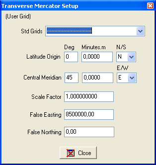
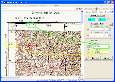
- Calibration of the map can be done either in latitude/longitude coords using the info at the map corners, or using the numbers on the map grid (which is 2x2 km). If you use the map grid, you also get a cross-check if you did the map projection setup right - you would get a nonsense lat/lon info if not. Note that the numbers you enter are in the TM units (e.g. meters), so 1000x what you read on the grid.
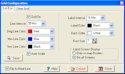
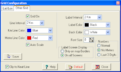
- Switch on the grids to see if everything is OK. This is done via the Map/Grid Line Setup menu item. For suggested configuration see the images below. It might be necessary to select/unselect/select the Auto scale to actually get a visible grid.
 Now you should have a calibrated map with both grids active and correctly set up. Note that the display datum should be set to User grid, not UTM.
This is about the OziExplorer setup. Now the question is, how to setup the Garmin GPS accordingly. The goal would be to be able to get a position in the 1942 grid from the GPS and be able to easily locate oneself on the map.


